terrain following system — vietovės reljefo sekimo sistema statusas T sritis Gynyba apibrėžtis Sistema, kuri orlaivio pilotui ar autopilotui pateikia kilimo ar pikiravimo signalus taip, kad orlaivis galėtų kaip galima tiksliau išlaikyti pasirinktą aukštį virš žemės… … NATO terminų aiškinamasis žodynas
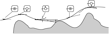
terrain following system — A system which provides the pilot or autopilot of an aircraft with climb or dive signals such that the aircraft will maintain as closely as possible a selected height above a ground contour in a vertical plane through the flight vector … Military dictionary
terrain clearance system — A system which provides the pilot, or autopilot, of an aircraft with climb or dive signals such that the aircraft will maintain a selected height over flat ground and clear the peaks of undulating ground within the selected height in a vertical… … Military dictionary
Terrain-following radar — (TFR) is an aerospace technology that allows a very low flying aircraft to automatically maintain a relatively constant altitude. It is sometimes referred to as ground hugging or terrain hugging flight. The term nape of the earth flight may also… … Wikipedia
fonction “suivi du terrain” — vietovės reljefo sekimo sistema statusas T sritis Gynyba apibrėžtis Sistema, kuri orlaivio pilotui ar autopilotui pateikia kilimo ar pikiravimo signalus taip, kad orlaivis galėtų kaip galima tiksliau išlaikyti pasirinktą aukštį virš žemės… … NATO terminų aiškinamasis žodynas
terrain-clearance radar — A specialist radar system that helps in flying from peak to peak rather than accurately following the terrain contours. Aircraft maintains a pre set height and is warned of obstructions, which are at a pre set slant range away. The instructions… … Aviation dictionary
rocket and missile system — ▪ weapons system Introduction any of a variety of weapons systems that deliver explosive warheads to their targets by means of rocket propulsion. Rocket is a general term used broadly to describe a variety of jet propelled missiles… … Universalium
Christchurch tramway system — A Christchurch Tramway tram, Worcester Street (March 2005) Operation Loca … Wikipedia
Controlled flight into terrain — CFIT redirects here. For the Canadian radio station in Airdrie, Alberta, see CFIT FM. A piece of the remains of Air New Zealand Flight 901, which crashed in 1979. All 257 people on the plane were killed. Controlled flight into terrain (CFIT)… … Wikipedia
Geographic information system — GIS redirects here. For other uses, see GIS (disambiguation). A geographic information system, geographical information science, or geospatial information studies is a system designed to capture, store, manipulate, analyze, manage, and present… … Wikipedia
 The target spot represents the path the aircraft should be following to clear the ground ahead by the required amount and the aiming mark is its present path.